Convert XYZ ASCII Elevation
The Convert XYZ ASCII Elevation tool converts XYZ ASCII files to GRW (binary Geo-Row) files for use as elevation sources for TerraBuilder Projects.
The XYZ file must contain a uniform grid of points (the geographical space between every two points must be equal in X-axis and Y-axis) and it cannot have any header (it must start with an X Y Z triplet). Each point is identified by its X, Y, Z coordinates.
See “GRW Plug-in” in the “Layer Management” chapter for more information.
To convert an XYZ ASCII file to GRW Format:
1. On the Tools tab, in the Convert group, click Convert XYZ ASCII Elevation. The Convert XYZ (ASCII File) to GRW dialog box opens.

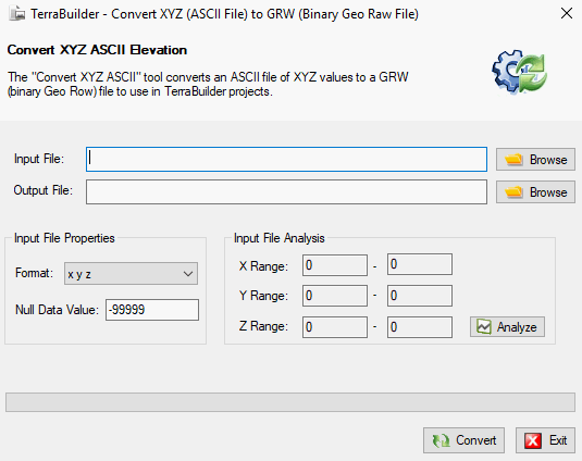
Convert XYZ (ASCII File) to GRW (Binary Geo Raw File) Dialog Box
2. Enter the following information:
|
Field |
Description |
|
Input File |
Browse to the XYZ ASCII input file, or type its path and name. |
|
Output File |
Browse to the target GRW output file, or type its path and name. |
|
Format |
Select the format of the XYZ triplets: § X Y Z - Values separated by spaces. § X, Y, Z - Values separated by commas. § Xh:Xm:Xs Yh:Ym:Ys Z - X and Y values are in degrees (Hour:Minute:Second), the Z value is in Units. |
|
Null Data Value |
The Z value (the elevation) of some of the points in the XYZ file, can optionally be null, in this case it is set to the minimum Z value in the file. For example, if the null data value is -99999, and the minimum Z value in the file is 0, the Z value of every point in the file with Z value -99999, is set to 0. |
3. If you want to analyze the input file, click Analyze. The X Range, Y Range, and Z Range values are displayed in the Input File Analysis section.
Note: Clicking the Analyze button displays the selected file’s geo-information before creating the GRW file. This process is performed automatically when you create a Geo Raw file.
4. Click Convert to create the GRW output file.
5. Click Exit to close the dialog.