Setting Output Format
The General tab contains the parameters for the terrain database obtained at the end of the project construction process.
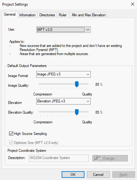
Project Settings - General Tab
|
Field |
Description |
|
Use |
Select an output format from the list. MPT v3.0 features support for several image and elevation formats: For imagery layers: § JPEG v3- For basic raster imagery that does not require transparency. § PNG-24 - For high-quality images. § PNG-Palette - For schematic maps using less than 256 colors. For elevation layers: § JPEG v3- For standard resolution. § PNG-16 - For high resolution, best for LIDAR data. § PNG 16.8 - For very high resolution. |
|
Image Format |
Select the required image format. |
|
Image Quality |
Adjust the compression-quality slider. If the slider is moved all the way to the left, the file produced is compressed and light. If the slider is moved towards the right, the quality of the image in the output file is increased. Note: This slider is enabled only in JPEG v3 and v2. |
|
Elevation Format |
Select the required elevation format. |
|
Elevation Quality |
Adjust the compression-quality slider. If the slider is moved all the way to the left, the file produced is compressed and light. If the slider is moved towards the right, the quality of the elevation imaging in the output file is increased. Note: This slider is enabled only in JPEG v3 and v2. |
|
High Source Sampling |
When this check box is selected, TerraBuilder reads the source file information from a higher resolution level than the one being created. This maintains the best quality of the layer in the output file. Note: Generating the output file is slower when this option is selected. |
|
Optimize Size |
When this check box is selected, the size of the terrain database is reduced. The reduction is particularly large when there is a significant resolution difference between image layers and elevation layers covering the same area. It is recommended to always select this option unless you want your terrain database to be available to TerraExplorer clients with an earlier version than v5.0. |