Adding a Navigation Map to the Navigation Map Window
To add new maps to the Navigation Map window:
1. On the Navigation tab, in the Map group, click Map. The Navigation Map Settings dialog is displayed.
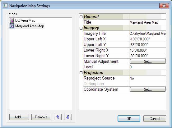
Navigation Map Settings
2. Click Add. The Open dialog is displayed.
3. Browse to the required map and click Open.
Note: The Navigation Map supports the same file formats and servers as are supported for raster layers. See “Loading Raster Layers” in the “Imagery and Elevation Layers” chapter for information. It is strongly recommended to use a compressed format (JPEG or GIF) and not BMP, for Navigation Maps. This ensures maximum performance with slower Internet connections.
4. In the Navigation Map Settings dialog, define the property sheet parameters as required.
5. If the map is not referenced to the coordinate system of the terrain, do either of the following:
§ Reprojection - When the map is referenced to a different coordinate system than the coordinate system of the terrain. See “Reprojecting a Navigation Map” in this chapter for further information.
§ Manual Adjustment - When the map is not referenced to any coordinate system. See “Adjusting a Navigation Map Manually” in this chapter for further information.