Terrain Database
The Terrain Database tab determines the terrain source and settings and sets and restores the terrain coordinate system.
By default, the terrain coordinate system is read from the terrain database. However, in rare cases where you know the coordinate system does not exist in the terrain database, or is incorrect, you can define it manually.
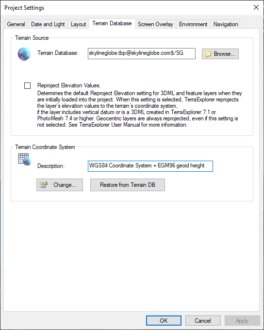
Project Settings - Terrain Database Tab
Enter the following information:
|
Parameter |
Activity |
|
Terrain Source |
|
|
Terrain Database |
The name of the local or remote MPT database currently used by this project. To change the project’s MPT database: § Click the Browse button and select a different MPT database. Make sure that the new MPT has the same coordinate system and covers the same area as the original MPT, or the content of the project will be unusable. |
|
Reproject Elevation Values |
Determines the default Reproject Elevation setting for 3DML, elevation, and feature layers when they are initially loaded into the project. When this setting is selected, TerraExplorer reprojects the layer’s elevation values to the terrain’s coordinate system, if the layer includes vertical datum or is a 3DML created in TerraExplorer 7.1 or PhotoMesh 7.4 or higher. Geocentric layers are always reprojected, even if this setting is not selected. |
|
Terrain Coordinate System |
|
|
Description |
Free text field (Read-only). |
|
Change |
Click to open the Coordinate System dialog. This high-level dialog allows you to select, view, edit and create a new coordinate system. See “Coordinate System Dialog” in the “Basic Concepts” chapter for information. |
|
Restore from Terrain DB |
Restores the coordinate system that is available from the MPT file. |