Volume Tool
The Volume Analysis tool analyzes the volume of the terrain or model removed or added by selected horizontal planes or modify terrain/3DML objects.
Using the Volume Analysis Tool
To use the Volume Analysis tool:
1. On the Analysis tab, in the Terrain Analysis group, click Volume. The Volume Analysis dialog is displayed.
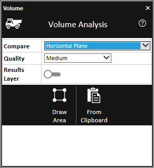
Volume Analysis Tool
2. In the Compare field, select one of the following analysis modes:
§ Horizontal Plane – Calculate the volume added or removed by a horizontal plane defined either by a polygon you now draw or by polygons already on the clipboard.
§ Modify Terrain – Draw New – Calculate the volume added or removed by a new Modify Terrain object that you now create.
§ Modify Terrain – Select Existing – Calculate the volume added or removed by the Modify Terrain object(s) selected from the list.
3. Enter the required parameters:
|
Parameter |
Description |
|
Select |
This field is displayed only when Modify Terrain – Select Existing mode is selected. Select one or more Modify Terrain objects from the list. Use CTRL-click or SHIFT-click to multi-select. Click Refresh list to update the list if changes were made to the project. |
|
Quality |
Determines the accuracy level by which the analysis is performed. Select one of the following options: § Low – Performs 16K samples § Medium – Performs 65K samples § High – Performs 260K samples |
|
Results Layer |
Toggle the switch on to create a point shapefile representing each volume analysis result. The area and volume (removed or added) of each sample in the feature layer is stored in the Volume Area and Volume Difference attribute fields of the feature that represents the sample. |
4. Perform the steps relevant to the selected mode:
Horizontal Plane Mode
§ Select either of the following methods to mark your area of interest:
· Draw Area – The area is marked by drawing a polygon in the 3D Window. If this option is selected, left-click in the 3D Window to place the polygon waypoints, and right-click to complete.
· From Clipboard – Analysis is performed in the locations of all polygon clipboard objects. The polygons must be on the clipboard before selecting this option.
Modify Terrain – Draw New Object Mode
a. Click Start Calculation. The Modify Terrain property sheet is displayed.
b. In the 3D Window, left-click to place the polygon waypoints, and right-click to complete.
c. Close the property sheet to start calculation.
Modify Terrain – Select Existing Mode
a. In the Select field, select one of the project’s modify terrain objects.
b. Click Start Calculate.
· Draw Area – The area is marked by drawing a polygon in the 3D Window. If this option is selected, left-click in the 3D Window to place the polygon waypoints, and right-click to complete.
· From Clipboard – Analysis is performed in the locations of all polygon clipboard objects.
5. When calculation is complete, a dialog is displayed with the analysis results.