Standard Units, Time Formats and Angular Representations
Units
Although a TerraExplorer user can control the display and editing units of several types of parameters, the COM interface always uses the same types of units.
Unit definitions:
§ X, Y Coordinates – The X and Y coordinates should be presented in the same coordinate system that the project’s terrain database uses. For Lat-Long terrains, a decimal Lat-Long presentation should be used.
§ Altitude and Height – Altitude and height values should be presented in meters above ground. For 2D primitives you can use meters above the object’s pivot point.
§ Distance – Distances and dimensions of objects should be presented in meters.
§ Speed – Speed should be presented in meters per second.
Yaw, Pitch and Roll Angles
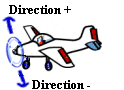
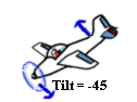
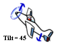
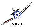
The yaw (direction), pitch (tilt) and roll values are defined as described in the following diagram.

Yaw values
Range from 0 to 360 where 0=North, 90=East, 180=South and 270=West. TerraExplorer Pro adjusts illegal values to this range by modulating the illegal number.
Pitch values
Range from -90 to +90 where 0 = horizon, +90 = straight up and –90 = straight down. TerraExplorer Pro adjusts illegal values to this range by modulating the illegal number.

Roll values
Range from -90 to +90 where 0 = horizon, +90 = full roll right and –90 = full roll left. TerraExplorer Pro adjusts illegal values to this range by modulating the illegal number.


Time
Time values can be expressed as any of the following:
§ JavaScript Date object
§ VT_DATE
Note: DateTime (e.g. in JavaScript) is automatically converted to VT_DATE.
· _time_t
Int or long values representing the number of seconds elapsed since 00:00:00 on January 1, 1970, Coordinated Universal Time.
· double
Double values representing the number of milliseconds elapsed since 00:00:00 on January 1, 1970, Coordinated Universal Time.
§ C# DateTime object.