About the Project Tree
The Project Tree provides quick access to TerraExplorer Pro elements, enabling you to control the appearance of information in the 3D Window. Project Tree elements can be arranged in groups, according to function, type of information, or location.
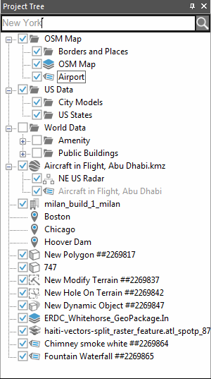
The Project Tree
Note: Clicking once on a Project Tree item selects the item, whereas double-clicking performs its activation action.
The Project Tree contains the following elements:
|
Element |
Icon |
Description |
|
Group |
|
A folder containing a collection of objects. § Double-click the group name or the Expand/Collapse icon Note: A locked group whose folder is always in collapse mode and cannot be opened by TerraExplorer Viewer user has no Expand/Collapse icon |
|
Feature Layer - Polygons |
|
A polygon feature layer is a group containing visual representation of geographic data using geographic polygon objects. |
|
Feature Layer - Polylines |
|
A polyline feature layer is a group containing visual representation of geographic data using geographic polyline objects. |
|
Feature Layer - Points |
|
A point feature layer is a group containing visual representation of geographic data using geographic points. |
|
Location |
|
Pre-defined location on the 3D Window. § Double-click on the location icon to fly to the location or to perform a flight pattern around it. |
|
Presentation |
|
Recorded flight path and view of terrain. § Click on the presentation icon to play the presentation. |
|
Label |
|
Text or image label. § Double-click on the label icon to fly to the label, perform a flight pattern around it or view the label from a different direction. |
|
Static Object |
|
2D or 3D static object. § Double-click on the object icon to fly to the object, perform a flight pattern around it or view the object from a different direction. |
|
Imagery, Elevation Layers |
|
Imagery or Elevation layer |
|
Dynamic Object |
|
2D or 3D dynamic object. |
|
Message |
|
Project Tree message. |
|
Contour Map |
|
Contour map of a selected area or the entire terrain. § Double-click on the Contour Map icon to fly to it, perform a flight pattern around it or view it from a different direction. |
|
Slope Map |
|
Slope map of a selected area or the entire terrain. |
|
Line of Sight |
|
Line of Sight marker. § Double-click on the Line of Sight icon to fly to the marker, perform a flight pattern around it or view it from a different direction. |
|
Best Path |
|
Best Path calculation object. § Double-click on the Best Path icon to fly to the calculation object, perform a flight pattern around it or view it from a different direction. |
|
Modify Terrain |
|
Modify Terrain object. § Click on the Modify Terrain icon to fly to it, perform a flight pattern around it or view it from a different direction. |
|
Hole on Terrain |
|
Hole on Terrain object. § Double-click on the Hole on Terrain icon to fly to it, perform a flight pattern around it or view it from a different direction. |
|
Video On Terrain |
|
The Video On Terrain feature plays a video file onto any selected area of the terrain. § Double-click on the video icon to fly to it, perform a flight pattern around it or view it from a different direction. |


Showing and hiding objects
Click the group’s show/hide icon  to display or hide all of the group’s children on the 3D Window.
The show/hide feature is also available for each child on the group. Groups with some children in show mode and others in hide mode display the following  icon.
icon.
The show/hide feature is relevant for labels, and static and dynamic objects. It has no effect on locations, presentations or Project Tree messages.
Showing objects in the TerraExplorer Viewer Project Tree
All locations, presentations and Project Tree messages always appear in the Project Tree when a TerraExplorer Basic Viewer opens the .FLY project. Objects, by default, also display in the Project Tree when TerraExplorer Viewer opens a .FLY project, but their display settings can be changed using their "Show in Viewer" parameter.
To change display settings, do either of the following:
§ Open the property sheet for a single object or group of objects and change the Show in Viewer parameter to Yes to display the objects in the TerraExplorer Viewer Project Tree or No to hide it.
or
§ In the Project Tree, right-click the required object, and then toggle the Show in Viewer Project Tree option on the shortcut menu.
Note: If all the children in a group are not shown on the Basic Viewer Project Tree, the group itself is removed.
The root
The blank area of the Project Tree is called the "root area". The leftmost area on the side of the Project Tree is called the "root folder"
You can place elements or groups directly in the root (as described below), or as part of other groups.
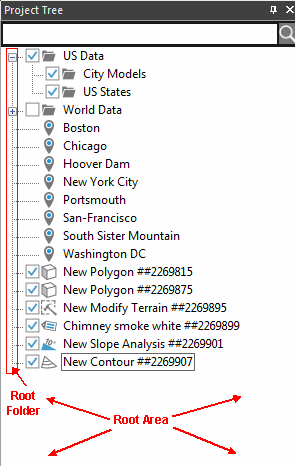
Root
Search tool
Using the TerraExplorer search tool located at the top of the Project Tree, you can search for any of the following:
§ Items in your project tree, including locations, layers, groups and objects.
§ Addresses and points of interest on your SkylineGlobe Server. The search bar supports multiple coordinate formats.
§ Layers and projects on your SkylineGlobe Server, including feature, 3D, raster, and point cloud.
§ TerraExplorer ribbon commands, e.g., Publish, Viewshed, or Animation. (The search results will include all commands with the search term and the related tooltip).
§ Feature attributes in a selected feature layer.
§ Specific coordinates.
For more efficient and effective searches, search filters can be used to narrow the scope of your search, using the syntax ‘Filter: search term.
To search:
1. In the Project Tree, Search here field, type a search term.
2. If you want to filter your search, use the syntax Filter: search term. See "Search Filters" in this chapter for information about available filters.
3. If you want to search for feature attributes in a selected feature layer, do the following:
a. In the Project Tree, right-click the feature layer and click "Search". The layer’s name is inserted in the search bar.
b. Add your search term after the colon that follows the layer name, i.e. [World Data\OSM Roads\OSM Roads Level 3]: Search Term.
4. When clicking on a search result, the operation that TerraExplorer performs depends on the result type selected:
§ Commands: - Activates the command.
§ Project: - Selects the item on the project tree and flies to its location.
§ Addresses: - Flies to the address location.
§ SkylineGlobe: - Loads the layer.
§ [Feature Layer]: - Flies to the feature location.
To fly to a specific coordinate:
In the Project Tree, Search here field, type the coordinates using the following formats:
Keywords (UTM, GEO, EPSG, MGRS) are not case sensitive.
§ Coordinates Without Specifying a Coordinate System
(Works only if the coordinates match the project’s coordinate system)
§ 34.41550 E / 31.47346 N
§ 34.41550,31.47346
§ 34.41550 31.47346
§ 3492613.94 N / 641829.21 E
§ 3492613.94 641829.21
§ Geographic (Lat-Long)
§ GEO 34.41550 E / 31.47346 N
§ WGS84 GEO 34.41550 E / 31.47346 N
§ UTM
§ UTM 36N 641829.21 E / 3492613.94 N
§ WGS84 UTM 36N 641829.21 E / 3492613.94 N
§ EPSG
§ EPSG:2039 193476.89 E 586022.93 N
§ MGRS
§ MGRS: 52KGU4641949353
§ 52KGU4641949353
Search filters
The following filters enable you to search for items from a specific source:
§ 'project:’ (or ‘p:’) search term - Searches only items in the project tree.
§ 'command:’ (or ‘c:’) search term - Searches only TerraExplorer ribbon commands.
§ 'address:’ (or ‘a:’) search term - Searches only addresses in your SkylineGlobe Server.
§ 'skylineglobe:’ (or ‘sg:’) search term - Searches only layers and projects in your SkylineGlobe Server
The following filters restrict the search results to items of a specific type:
§ 'Group:’ search term - Searches the project tree only for groups
§ 'Layer:’ search term - Searches only for feature/raster/3D/point cloud layers
§ '3DML:’ search term - Searches only for 3D (3DML) layers
§ 'Raster:’ search term - Searches only for imagery/elevation layers
§ 'Imagery:’ search term - Searches only for imagery layers
§ 'Elevation:’ search term - Searches only for elevation layers
§ 'Feature:’ search term - Searches only for feature layers
§ 'CPT:’ search term - Searches only for point cloud (cpt)