Insert Layer from File
To insert a layer from a file:
1. On the Home tab, in the Layers group, click Insert Imagery or Insert Elevation. The Insert Imagery/Insert Elevation dialog box opens.
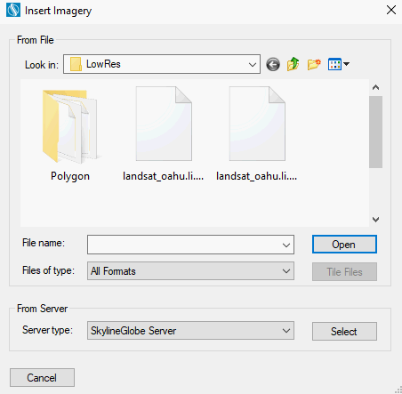
Insert Imagery Dialog Box
Note: If you want to restrict your Browse list to files of a specific format, in the Files of type field, select the required format.
2. Browse to the required file and select it.
3. If you selected multiple files and want to tile them, click Tile Files. See “Tiling Files” in this chapter for more information.
4. Click Open. If the source file includes coordinate system information that TerraBuilder can read from the file, the file directly opens.
If the source file does not include coordinate system information or TerraBuilder cannot read it from the file, the Coordinate System dialog box is displayed. Enter the source file’s coordinate system information. See “Setting a Source’s Coordinate System” in this chapter for more information.
Note: If you inserted a RAW, IMG (Erdas Imagine), or NGA, format files, a dialog box is displayed in which you can define properties for the relevant file type. If you inserted a GeoPackage format file, a dialog box is displayed in which you can select the required layer. See “RAW Plug-in”, “IMG Plug-in”, “NGA Plug-in”, and “GeoPackage Plug-in” in this chapter for more information.
5. After the layer has been loaded into the project, you can change its properties using the property sheet. See “Imagery and Elevation Layer Parameters” in this chapter for further information.