Streamline site inspections, monitor construction progress, and unify data on a single platform
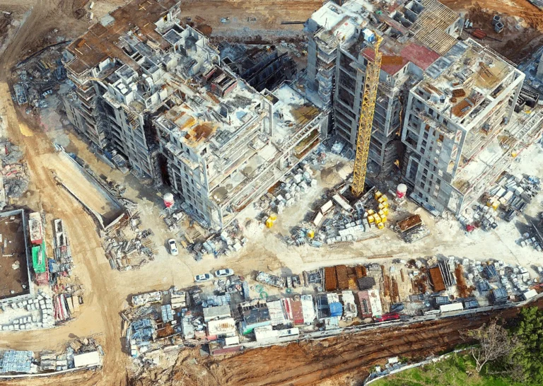
Our PhotoMesh software transforms aerial and ground photos, along with LiDAR data, into high-resolution 3D mesh models with survey-grade accuracy. These models are easily integrated into TerraExplorer, which provides a robust GIS platform for detailed visual planning, analysis, and querying.
TerraExplorer further enriches this integration by combining detailed mesh models with BIM and CAD technologies. This synthesis enhances visualization and provides crucial insights into how new structures will interact with their environments, fostering more sustainable and functional designs. With bidirectional data exchange and broad compatibility with various BIM and CAD platforms, Skyline’s software ensures a seamless and integrated design process, helping AEC professionals manage projects precisely from inception to completion.
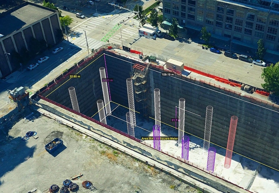
Skyline’s TerraExplorer delivers comprehensive analytical capabilities that transform raw spatial data into actionable construction intelligence. Its sophisticated change detection and comparison features streamline development tracking over time, allowing you to easily compare new construction data against original design datasets to ensure consistency and accuracy while identifying any deviations from planned specifications.
The platform’s extensive analysis toolkit extends beyond comparison to include powerful volume calculations for material estimation, advanced flood simulation for site drainage planning, shadow projections for optimizing building placement, viewshed analysis for assessing visual impact on surrounding areas, and much more. Construction teams can create more effective solutions through TerraExplorer’s analytical tools, which integrate contextual data and merge information from both above-ground and subterranean features into a comprehensive visualization environment.

Enhance safety and efficiency with remote inspection capabilities. Our tools enable clients to perform thorough inspections, rapidly identify potential issues, and generate detailed reports, all from the 3D model. This process not only streamlines inspections but also fosters transparency and collaboration among stakeholders.
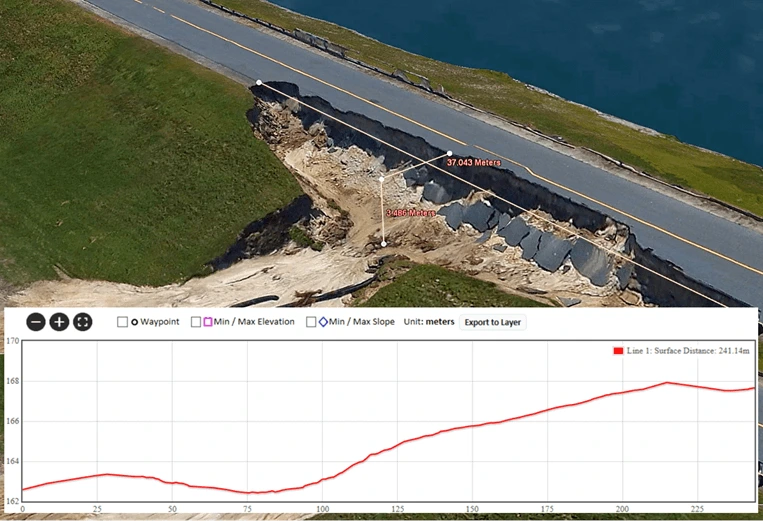
TerraExplorer's Photo Inspector provides a set of drawing and measurement tools to mark areas and locations on the model and generate a detailed report with all inspection details, streamlining the inspection process and enhancing transparency and collaboration.
Robust REST APIs allow developers to create, monitor, and manage project queues and to automate PhotoMesh production flows on local machines, remote servers, and the cloud.
TerraExplorer combines detailed mesh models with BIM and CAD technologies, enhancing visualization and providing crucial insights. TerraExplorer offers broad compatibility with various BIM and CAD platforms.
PhotoMesh can run its efficient algorithms fluidly on standard GPUs, or exploit multi-core and multi-computer processing to further accelerate database creation. A single project can run simultaneously on hundreds of fuser machines, processing tens of km2 per day.
PhotoMesh can exploit computer clusters and cloud computing to run a single project simultaneously on hundreds of fuser machines. Sharing the workload involved in generating PhotoMesh output vastly accelerates the build process.
Intuitive GUI and powerful, versatile tools for accurate evaluation and adjustment of your input data and AT, including: a coverage map, photo inter-connection map, Lidar data integration, control points, photo projection on terrain and Lidar and much more.

PhotoMesh

SkylineGlobe Server
TerraExplorer
© Skyline Software Systems Inc. 2024, All Rights Reserved, Skyline HQ Herndon Virginia
| Cookie | Duration | Description |
|---|---|---|
| cookielawinfo-checkbox-analytics | 11 months | This cookie is set by GDPR Cookie Consent plugin. The cookie is used to store the user consent for the cookies in the category "Analytics". |
| cookielawinfo-checkbox-functional | 11 months | The cookie is set by GDPR cookie consent to record the user consent for the cookies in the category "Functional". |
| cookielawinfo-checkbox-necessary | 11 months | This cookie is set by GDPR Cookie Consent plugin. The cookies is used to store the user consent for the cookies in the category "Necessary". |
| cookielawinfo-checkbox-others | 11 months | This cookie is set by GDPR Cookie Consent plugin. The cookie is used to store the user consent for the cookies in the category "Other. |
| cookielawinfo-checkbox-performance | 11 months | This cookie is set by GDPR Cookie Consent plugin. The cookie is used to store the user consent for the cookies in the category "Performance". |
| viewed_cookie_policy | 11 months | The cookie is set by the GDPR Cookie Consent plugin and is used to store whether or not user has consented to the use of cookies. It does not store any personal data. |