
PhotoMesh is now part of the SceneCast solution package, enabling a complete end-to-end workflow from drone survey to simulation-ready terrain
OneArc’s SceneCast now ships with Skyline PhotoMesh as an integrated component, giving operators a seamless photogrammetry pipeline directly within the SceneCast solution package.
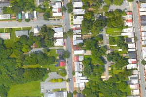
Operators fly UAV/drone missions over the area of interest, capturing overlapping imagery from multiple angles.
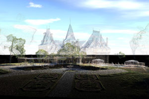
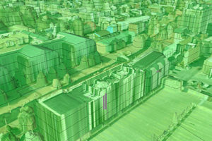
PhotoMesh converts the overlapping imagery into accurate, high-resolution 3D mesh models using photogrammetry — on the SceneCast laptop, in the field.
OneArc’s Mantle software processes the 3D mesh into simulation-ready terrain and exports to all major simulation formats.
Terrain loads directly into VBS4 and other sim environments. Troops train and rehearse missions in a realistic virtual replica of the actual AO.
PhotoMesh enables rapid turnaround from data capture to simulation-ready terrain. It can operate efficiently on standard GPUs or scale across multiple cores & machines, enabling hundreds of fuser machines to process tens of square kilometers per day.
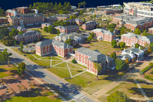
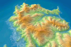
PhotoMesh generates a full-3D mesh model that faithfully reproduces even small-scale details such as cars, trees, fences, and walls - all with advanced color balancing and high-quality texturing.
PhotoMesh is designed to handle city-scale and country-scale datasets, enabling large-area simulations without compromising performance.
Eliminate the need for manual 3D modeling by leveraging automated workflows on local machines, remote servers, and the cloud, reducing both production time and operational cost.
Through the Mantle pipeline, PhotoMesh meshes can be exported to VBS4, standard IG formats, OBJ, DAE, and other simulation-ready formats - ensuring compatibility across the customer's existing toolchain.
PhotoMesh is provided as part of OneArc's global reseller agreement, eliminating the need for a separate vendor relationship. Its output integrates directly into SceneCast pipelines, supporting efficient ingestion, streaming, and visualization within simulation scenarios.
| Cookie | Duration | Description |
|---|---|---|
| cookielawinfo-checkbox-analytics | 11 months | This cookie is set by GDPR Cookie Consent plugin. The cookie is used to store the user consent for the cookies in the category "Analytics". |
| cookielawinfo-checkbox-functional | 11 months | The cookie is set by GDPR cookie consent to record the user consent for the cookies in the category "Functional". |
| cookielawinfo-checkbox-necessary | 11 months | This cookie is set by GDPR Cookie Consent plugin. The cookies is used to store the user consent for the cookies in the category "Necessary". |
| cookielawinfo-checkbox-others | 11 months | This cookie is set by GDPR Cookie Consent plugin. The cookie is used to store the user consent for the cookies in the category "Other. |
| cookielawinfo-checkbox-performance | 11 months | This cookie is set by GDPR Cookie Consent plugin. The cookie is used to store the user consent for the cookies in the category "Performance". |
| viewed_cookie_policy | 11 months | The cookie is set by the GDPR Cookie Consent plugin and is used to store whether or not user has consented to the use of cookies. It does not store any personal data. |
For security purposes, please solve this simple puzzle to verify you are human before sending an OTP.