We are excited to announce our latest innovation: the Virtual 3D Layer, designed to solve tough challenges in enterprise-level 3D mesh and Gaussian Splatting data management.
With our Virtual 3D Layer, you can:
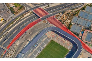
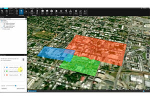
- Integrate multiple 3D datasets – even those from different times or sources – into a single, unified virtual layer.
- Clip and prioritize: Retain only the most relevant geographic areas from each source and set draw priorities to resolve conflicts between overlapping layers.
- Minimize data duplication: Our virtual layer references original source blocks using lightweight pointers, ensuring efficient storage and management.
- Easily maintain multiple virtual layers over the same geographic area, allowing you to snapshot different times or combinations of models for powerful temporal analysis and scenario comparison.
- Publish seamlessly: Once configured, the virtual layer can be published to SkylineGlobe Server, making it accessible to TerraExplorer Pro, Fusion, Mobile, Cesium, ESRI, and any 3D Tiles-compatible client.
This capability streamlines workflows for organizations working with large, complex, and evolving 3D geospatial datasets, enabling more precise analysis and visualization.