Herndon, VA – September 10, 2020 — Skyline Software Systems is proud to announce a partnership with AirMap, the leading digital airspace and automation company serving the drone economy.
(Read original press release HERE)
AirMap is excited to announce our partnership with Skyline Software Systems, a leading provider of 3D earth visualization software and services that offers a comprehensive platform of applications, tools, and services that enable the creation and dissemination of interactive, photo-realistic 3D environments. Our integration extends the power of the AirMap platform to architectural, engineering and construction customers and equips enterprises with cutting edge 3D technology allowing them to observe, experience, and solve for the unique challenges of their development projects.
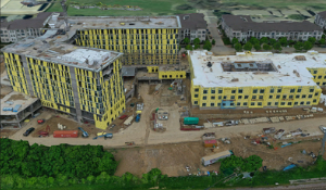
Enterprises can gain business insights from their drone captures by transforming raw images into 3D models and orthomosaics that produce a high-fidelity digital twin of their assets. AirMap’s integration with Skyline means AEC users will now be able to employ an integrated, cloud-based version of Skyline’s PhotoMeshUAV™ solution to convert their JobSight images into high-resolution 3D models for precise measurements and analysis. Users can also view, query, analyze, and present geospatial data within a suite of powerful tools in a high-resolution 3D environment. These capabilities enable JobSight users to conduct sophisticated project site analysis remotely. With highly detailed digital twins, AEC professionals can compare as-built models to their original plans. They can identify and resolve issues before they impact project progress, resulting in increased efficiencies, safer sites, and higher quality work. Skyline’s Cloud Processing enables users to scale up to as many projects, at any size, as needed, and ensures a timely and efficient data delivery schedule.
“Skyline Software is excited to bring high definition 3D digital twins to AirMap’s AEC customers,” said Skyline CEO Robert Peters. “Combining our automation platforms is a real game changer for construction development projects. AirMap’s enterprise users can now gain greater insights from their drone captures, process an integrated 3D model, and generate reports on development progress with accuracy, speed, and visual references.”
“AirMap is proud to work with Skyline and give JobSight users additional tools to gain valuable insights from their drone captures,” said AirMap CEO David Hose.
To learn more about how you can leverage drone technology to gain business insights, visit airmap.com/enterprise.
(Press Release courtesy of AirMap)