SkylineGlobe Server
Securely store & access 3D geospatial data where, when, and how you need it
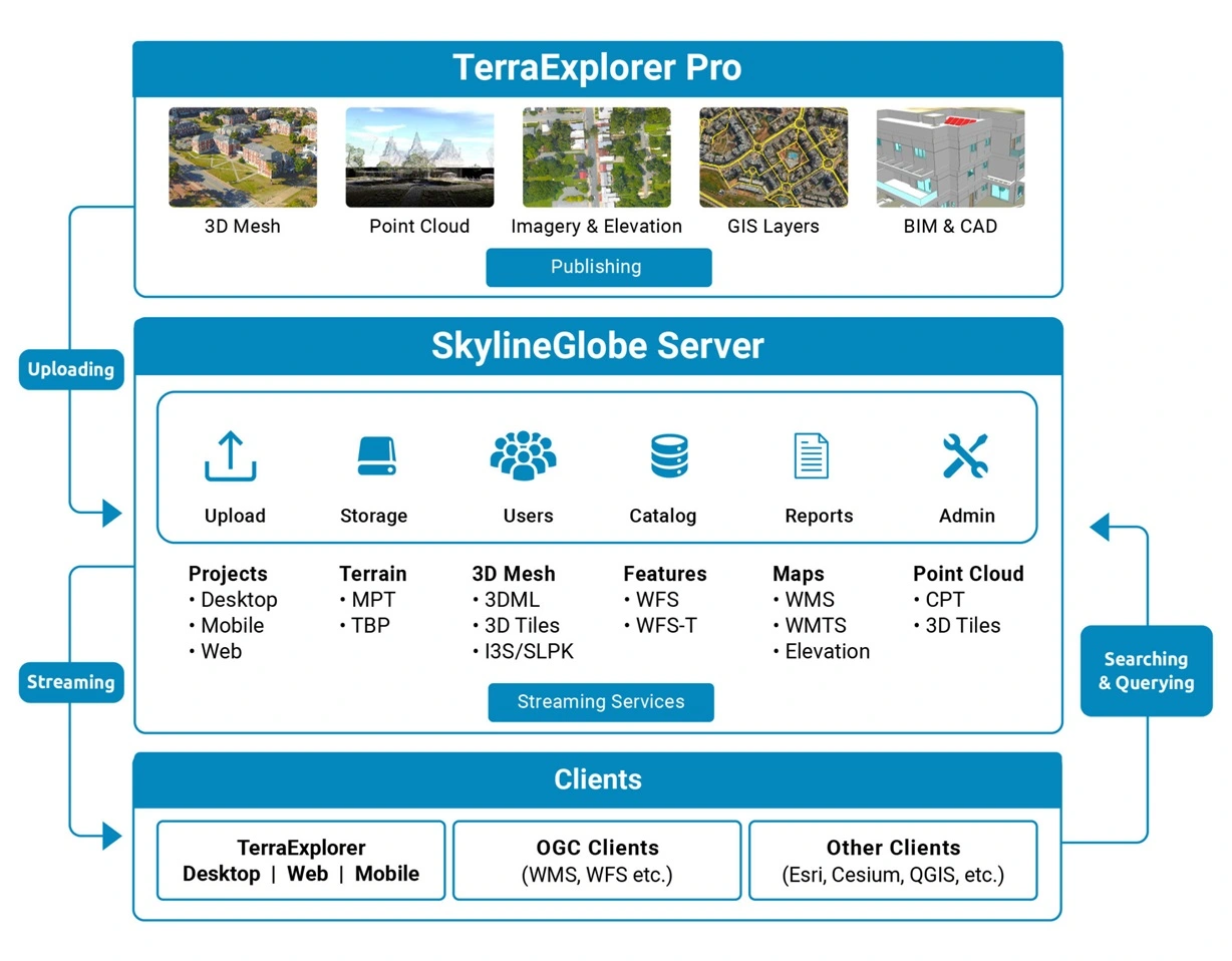
The SkylineGlobe Server private cloud solution provides a comprehensive set of web services for publishing, storing, managing and streaming 2D and 3D geospatial content. All your GIS layer types are supported: 3D mesh , imagery, elevation, feature and point cloud. SkylineGlobe Server makes it easy for you to share your data by converting and exposing your content in multiple formats.
Skyline Clients
Esri Clients
SkylineGlobe Server streams 2D and 3D layers to ArcGIS Earth, ArcGIS Pro and ArcGIS Online in their native formats:
- 3D mesh layers as I3S/SLPK
- Imagery using WMS or WMTS protocol
- Feature layers using WFS protocol
Esri and the Esri Logo are licensed trademarks of Environmental Systems Research Institute, Inc.
Cesium, QGIS and OGC Clients
SkylineGlobe Server streams data to Cesium, QGIS and other OGC clients in their native formats:
- 3D mesh layers as 3D Tiles
- Imagery and elevation using the WMS or WMTS protocol
- Point cloud layers as 3D Tiles
- Feature layers using either WFS protocol, or WFS-T to support edits to the data source
Data Flow
Data Security
Keep data safe with virtual private, geospatial servers, custom authentication, and user permissions. SkylineGlobe Server supports the hosting of multiple virtual servers (“sites”) on a single server. These virtual sites provide complete separation between customer layers and allow management and administration of the sites by the customer’s admin users. SGS also provides the option for full customization of your server’s authentication and authorization system, as well as an out-of-the-box custom authentication implementation.
Cloud Ready
For greater scalability, redundancy, and security, SkylineGlobe Server can use any cloud platform (AWS/Google Cloud/Azure, etc.) that provides virtual machines that meet Skyline’s system requirements. Skyline also offers SkylineCloud, a fully managed Skyline service based on SkylineGlobe Server, for uploading, storing, converting and streaming 2D and 3D spatial data, to help you optimize your geospatial data production.
Scalability and Elasticity
Add and adjust storage and compute capacity in real-time to accommodate increased or spikes in usage, as well as redundancy and failover, using dynamically clustered compute power. All servers in a cluster share a single floating license that can be passed from server to server. Cluster servers also share the maximum number of concurrent active end users defined in the license, with the load balancer determining the distribution of server traffic between the servers.
Streamlined Workflow
Upload and publish individual geospatial layers and complete projects to the cloud server directly from TerraExplorer Pro. Through a single publishing operation, data is made ready for consumption by all TerraExplorer clients: Desktop, Web and Mobile, as well as other 2D and 3D geospatial applications.
Interoperability
SkylineGlobe Server enables your enterprise to realize the full potential of 3D data, or make data available to other clients, including Esri, QGIS and Cesium-based viewers. SkylineGlobe Server can convert and expose data in a range of formats, while storing only the original data formats on the server.
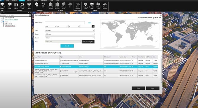
Data Catalog
Store massive amounts of geospatial data with automatic and manual extraction of metadata and geospatial information and support for advanced server-side search options. All data on your geospatial server is cataloged and referenced so clients can easily find the specific published layer required.
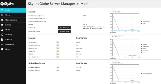
Convenient Centralized Web Management
Manage and control all services, servers, users, and layers from a centralized web management interface. The server’s built-in complete user access control system allows easy management of users, groups, and administrative roles controlling the server-side storage, and client-side read/write permissions, giving you ultimate control over how your data is used.