BELLEVUE, Wash., and HERNDON, Va. – EagleView, a leading geospatial technology provider of software, aerial imagery and analytics, and Skyline, a leading provider of 3D earth visualization software, today announced a partnership to enable customers to visualize their geospatial data in new ways.
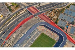
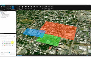
Through this new partnership, EagleView’s high-resolution ortho and oblique imagery can be converted into 3D Mesh layers with Skyline’s PhotoMesh and viewed, edited, and analyzed on Skyline’s TerraExplorer platform.
“The combination of EagleView’s high-resolution, quality imagery and the capabilities of PhotoMesh and TerraExplorer will give customers the chance to do and see more with their own data than they ever imagined.”
Robert Peters, CEO of Skyline Software Systems.
EagleView customers will be able to utilize Skyline’s TerraExplorer web-based GIS viewer and editor to see, analyze and share their imagery in an immersive environment. Accurately measuring distance, area and volume is now easier than ever, which is critical for planning and zoning to verify regulations or estimate costs of flattening a site. With floodplain analysis, disaster management can identify flood risks before they happen, and with viewshed calculations, E911 can pre-plan for high-profile events. Other key analytic features for customers will include the ability to analyze shade, view contour and slope maps, and view in underground mode.
“We’re excited about this partnership with Skyline and the opportunity to combine their 3D Mesh technology with our high-resolution imagery to enable enhanced insights in the TerraExplorer platform.”
“At EagleView, we constantly work towards innovation so customers can get the most out of our products. This partnership is a great example of how we’re pushing the boundaries of what imagery can do.”
Chris Jurasek, CEO of EagleView
Beginning immediately, the additional 3D Mesh capability is now available as an add-on to any new Reveal Essentials+ Property or Neighborhood image capture.
###
About Skyline
Skyline Software Systems, Inc. is a leading provider of 3D earth visualization software and services. Skyline offers a comprehensive platform of applications, tools, and services that enable the creation and dissemination of interactive, photo-realistic 3D environments. Skyline products are production proven in both the Defense and Commercial markets.
Visit us at www.skylinesoft.com
About EagleView
EagleView is a leader in geospatial technology, providing software, imagery and analytics that transform the way our customers work. EagleView has the largest geospatial data and imagery library in history, covering 94 percent of the U.S. population. EagleView’s unique technology with over 300 patents creates highly differentiated software, imagery and analytics products for a diverse customer base.
For more information, call (866) 659-8439, visit www.EagleView.com and follow @EagleViewTech.
Skyline Software Systems Inc
Jim Michel, US & Canada Business Development Manager
703-956-1617
EagleView
Patrick Gill